![]()
![]()
1933 FLOOD
1933 was unusual in that there were 2 floods that year. The first crested at 63.6' on March 21. The second crested at 54.1' on May 15. The post card above is a modern reproduction of, I believe, the second somewhat minor flood in May.
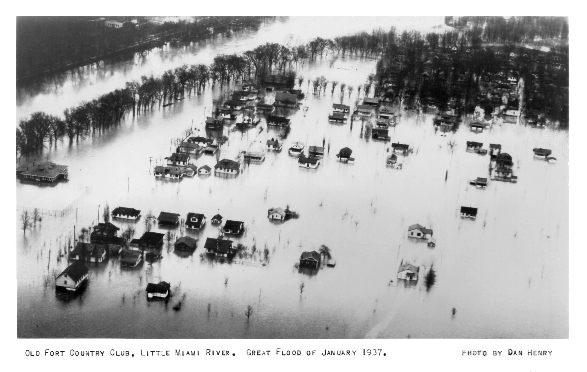
1937 FLOOD
The flood of 1937 was the highest the
Ohio had ever risen since any type of records were kept. The very first recorded
one in 1773 was measured at 76', which if true would have been the worst
flooding of the area until the 1937 one. Of course how accurate that one was is
debatable. The official height of the 1937 flood is listed at 79.99 feet. If
this number seems rather odd to you, it is and it has long been debated on.
Rumor has it, (but has never been proven) that had it officially reached 80 feet
double indemnity clauses in certain insurance contracts might have become
effective, and the companies would likely have been thrown into bankruptcy. For
all practical purposes, the Weather Bureau now accepts 80 feet. If you look
closely at the chart above you will actually see 80' listed for 8 hours! When the crest was reached 11 of Cincinnati's 72 square
miles was under water. Just picture this and I will shut up, Home Plate at
Crosley Field was under 20 feet of water.
The photo below shows the Island Queen
trapped between the bridges. The Queen and her wharf boat drifted several blocks
from her spot at the foot of Broadway.
1937 flood as seen from the Union Central Building, Cincinnati, OH - looking southeast at the ramp to the Roebling Suspension Bridge. Taken January 1937 by Nelson Ronsheim (copyright 2009, Michael G Smith)�
Crosley Field
card showing water nearly
covering lower grandstand
Salvation Army
roof
Union
Terminal
Ludlow
Viaduct
Industrial District
Suspension
Bridge
Fire in
Cumminsville
foot of Sycamore St.
Coney
Island
Coney
Island Big
4 & B&O Bridge
Suspension Bridge
Over
Big Miami
across the top of card
L. & N.
Bridge
View over Central
Bridge East End
Union Levee Columbia
Power Station
L. & N and Central
Bridges
Union Gas & Electric
Cincinnati Union Terminal
Beachmont
ramp
Newport, KY at
top
Beechmont
Levee East
End
Beechmont Bridge Over Little Miami
Both of These Cards Are in The Newtown Area
Lunken
Airport
Lunken
Airport
Union Terminal in
center
Cumminsville
The area around Lunken Airport is the site of the original Cincinnati. The original settlers had to move down river to the slightly higher elevation of the present Cincinnati because of the very bad flooding in this area.
George Schorr Co. Interior
2730 Spring Grove Ave.
Lower Price Hill
The George Schorr Co. was located at 1 West Pearl St. and was a wholesaler of notions.
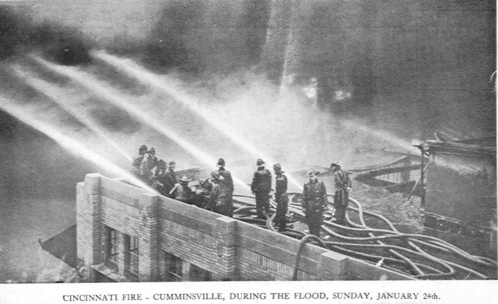
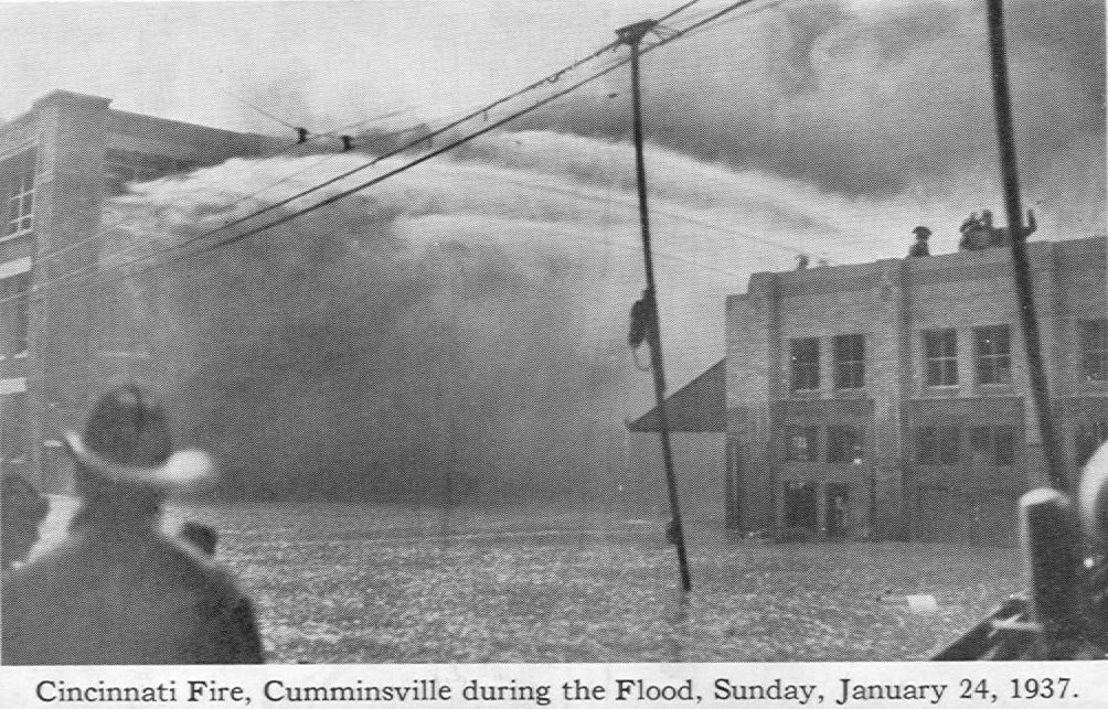
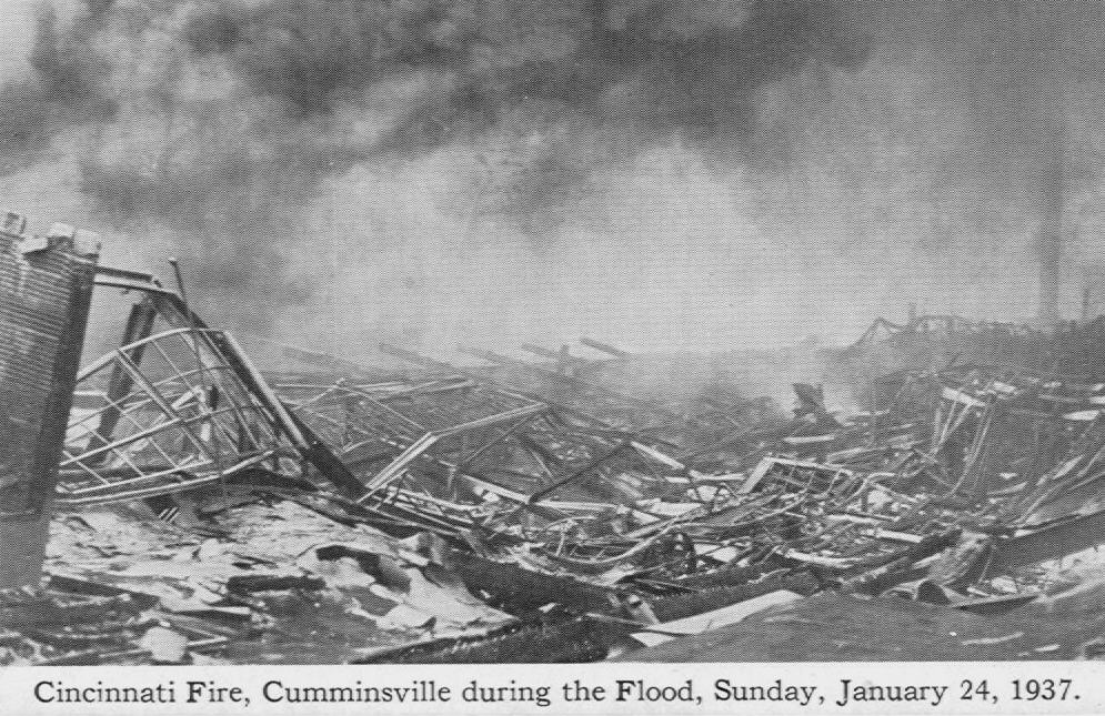
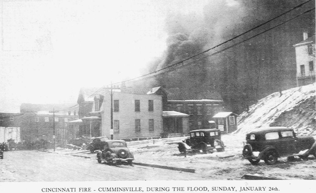
All four of these cards are views of the huge fire caused by gas storage tanks overturning and catching fire during the 1937 flood. Called The Black Sunday Fire it took more than 12 hours to put out and burned over three and a half square miles causing $1.5 million in damages (in depression day dollars).
The Zanol Products Co. (no information) This folder contains
14 pictures, (2 shown), of the 1937 Flood
CINCINNATI STREET RAILWAY FLOOD PAMPHLET
1937 FLOOD PHOTO STORY PAMPHLET
1937 FLOOD PHOTOGRAPHS
The following images are not postcards. I have come into possession of a group of photographs with detailed descriptions on the backs of most of them.
#1-The Island Queen and her wharf boat being towed to a new mooring. #2-View of Pearl St. with Island Queen in the distance and water still rising. #3- corner of Broadway and Pearl. Writer explains that this area is where fruit dealers set up their stands. You can see police in their boats bring people from their homes to dry land. #4- Bellevue (left) and Newport KY. (right) as seen from Mt. Adams. In between is where a ballpark was located.
#5-A warehouse at 4th & Smith Sts. with gas company behind it. Writer states that at no time was the city not without gas, although the phone, water and electric services were discontinued. #6- Broadway with the levee on the right. The collapsed building apparently trapped some people. #7-Near L & N Bridge at 3rd and Butler. Writer states that no one was allowed into Jones Restaurant without a pass to take pictures, and that they had no whiskey to sell by-the-glass for many a day, besides which the area was patrolled by the National Guard. #8- 3rd & Central with wreckage obstructing the view to the river straight ahead.
#9-This street is not identified by the writer, he calls it the Clinic block because he apparently had a clinic behind the camera. The view is facing the Ohio River and the writer states that the water had several more feet to rise and says due to the inclination of the street the water never reached his clinic that was on the next corner. #10-Scene after the flood at Coney Island. Writer states that these lockers were cemented down and thus were not washed away. The lockers he is referring to are the ones at Sunlite Pool. That is Kellogg Ave. at the bottom of the photo with looking over Sunlite above it. The pumping and circulation apparatus is seen near the center of the image. The lockers were located in the dressing rooms and shower area. #11-(Probably Eastern Ave.) A garage that had floated into its present position. #12-Eastern Avenue. A flat-bottomed boat that was used during the flood can be seen. The Red Cross pleaded for all these borrowed boats to be returned as most of them were abandoned.
#13-Eastern Ave. The 2nd floor of this house floated off the 1st floor and fell over when the flood receded. #14-Stanley and Kellogg Aves, just off Eastern Ave. The house floated onto its side and landed on the gas station lot. #15-(Eastern Ave?) One house floated onto the top of another house which collapsed when water receded. #16-Area referred to as "Turkey Bottom" near Eastern Ave. A graveyard of floating homes. The area refered to is south of Lunken Airfield along the Ohio between, roughly, Delta Ave. on the west to Wilmer Ave. on the east end.
House in the "Bottoms" The white square
on the far left center is a sign "Condemned by B. of H." (Board
of Health.)
I would like to thank Justin Lynch for help in identifying some of
these images.
I have taken present day photographs of the areas shown in the next group of 1937 flood photographs. I have tried to obtain the same angle that was used but due to changes it is not always possible to be completely accurate.
American Can Co.
Northside
Apple & Knowlton Sts. Northside
Blue Rock ST. from Jo Williams St.
Northside
Chase Ave. & Chambers St. Northside
Hamilton Ave. at Moline Court
Northside
Moline Court
Northside
Henshaw & Township Camp Washington
